Pilgrims have flocked to Mt. Ontake for centuries in search of enlightenment, undergoing purifying rites and rituals before climbing the Ontake Kodo Trail to the top of the mountain.
Much of the trail remains to this day, so you too can walk along the same road that pilgrims have traveled, take in the scenery of the forests and waterfalls at the base of Ontake, and visit numerous shrines along the way.
The main section of the Ontake Kodo Trail can be completed in a single day, and another trail continues to the very top of the mountain for interested climbers.
Learn more about the Ontake Kodo Trail below.
History of the Ontake Kodo Trail
The Ontake Kodo Trail refers to two separate paths leading to the top of Mt. Ontake: the Kurosawa route (26.8 kilometers) from Kiso Fukushima and the Otaki route (8.8 kilometers) from Otaki Village. These paths were once walked by mountain ascetics who sought enlightenment atop Mt. Ontake. Remnants of the area’s long history are scattered throughout the trail, from moss-covered shrines and statues to countless Reijinhi monuments dedicated to pilgrims past.

While the looming presence of Mt. Ontake has drawn reverence since the first people entered the valley, it was officially established as a place for spiritual practice by En-no-Ozunu at the beginning of the 8th century. Over the next thousand years, mountain ascetics flocked here seeking enlightenment, undergoing strict diets, and training before being allowed to climb to the peak. During the Edo period, Mt. Ontake was finally opened to the public as the object of the Ontake Faith. At the same time, the current paths to the peak were established, and members of the Ontake Faith have used these routes ever since.
Trail Overview and Access
The Ontake Kodo Trail begins in Otaki Village at the base of Mt. Ontake and climbs up to Hakkaisan Shrine around the Fifth Station (Gogōme) of Mt. Ontake. The full course takes approximately 5 to 6 hours to complete and covers a distance of 9 kilometers.

From there, a trail to the top of Mt. Ontake cuts through the Ontake 2240 Ski Resort and takes about 4.5 hours to complete roundtrip.
Access
To reach the start of the Ontake Kodo Trail, take the Seibu Kansen line bus from JR Kiso-Fukushima Station to Otaki Bus Stop (38 min.). The Otaki Village Tourist Information Center is a 1-minute walk from there.
On weekends between July and mid-October, you can also ride the Tanohara line bus, which connects JR Kiso-Fukushima Station to Ontake Tanohara Bus Stop at the end of Ontake Kodo Trail. If you’d like to start partway along the trail or take the bus back at the end, we recommend planning your hike according to the bus schedule.
Trail Sections

Section 1: Otaki Village Tourist Information Center to Ontake Satomiya Shrine
Distance: 949 meters
Elevation Gain: 75 meters
Estimated Time: 21 min. up / 21 min. down
Nearest Bus Stop: Otaki Bus Stop
Section 2: Kunza Bus Stop to Second Station (Nigōme)
Distance: 1,760 meters
Elevation Gain: 20 meters
Estimated Time: 36 min. up / 35 min. down
Nearest Bus Stop: Kunza Bus Stop
Section 3: Omata to Omata Sanso
Distance: 1,271 meters
Elevation Gain: 80 meters
Estimated Time: 25 min. up / 22 min. down
Nearest Bus Stop: Nigōme Bus Stop
Section 4: Kiyotaki Falls and Shintaki Falls to Junigongen
Distance: 2,500 meters
Elevation Gain: 260 meters
Estimated Time: 98 min. up / 86 min. down
Nearest Bus Stop: Kiyotaki Bus Stop
Section 5: Seseragi no Komichi to Gingamura Campgrounds
Distance: 1,185 meters
Elevation Gain: 180 meters
Estimated Time: 51 min. up / 37 min. down
Nearest Bus Stop: Ontake Kogen Bus Stop
Section 6: Hakkaisan-shita to Hakkaisan Shrine
Distance: 1,153 meters
Elevation Gain: 130 meters
Estimated Time: 32 min. up / 23 min. down
Nearest Bus Stop: Hakkaisan-shita Bus Stop
Section 7 (Unofficial): Hakkaisan Shrine to Tanohara Trailhead
Distance: Approx. 2.9 kilometers
Elevation Gain: 608 meters
Estimated Time: 2 hrs. 10 min. up
Nearest Bus Stop: Hakkaisan Bus Stop
Section 8 (Unofficial): Tanohara Trailhead to Mt. Ontake Summit
Distance: Approx. 3.4 kilometers
Elevation Gain: 811 meters
Estimated Time: 3 hrs. 10 min. up
Nearest Bus Stop: Tanohara Bus Stop
Highlights of the Ontake Kodo Trail
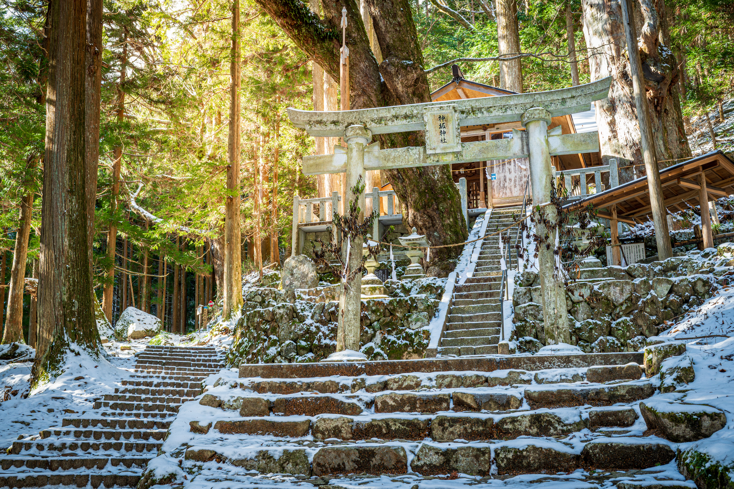
Ontake Satomiya Shrine

The Ontake Satomiya Shrine sits at the base of the Otaki route of the Ontake Kodo Trail. A long set of stone steps leads through forests of sawara and hinoki cypress trees to the wooden shrine hall at the base of a small cliff. The sound of rustling leaves and falling water drowns out any distractions as you make a prayer before starting your trek.
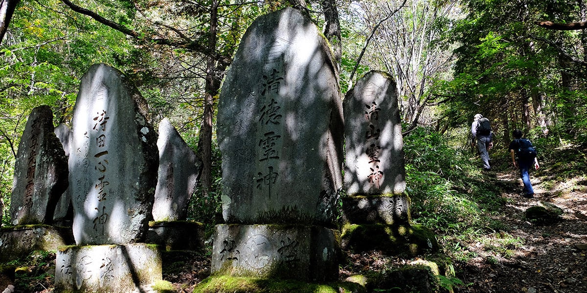
Reijinhi Monuments

Over 20,000 stone monuments known as Reijinhi line the trail at the base of the mountain. It is said that the spirits of followers of the Ontake Faith return to the mountain after they pass, and these monuments are each dedicated to a pilgrimage group, or kō. The name of the pilgrimage group is carved into the surface of the monument.
Kiyotaki and Shintaki Falls

These two 30-meter-high waterfalls were both used by mountain ascetics during their training before ascending Mt. Ontake. Ascetics would meditate under the relentless flow of Kiyotaki or in the cove directly behind Shintaki. Stone monuments and small shrines can be found around both, as well as a small hut used by pilgrims to Mt. Ontake even to this day.
Tanohara

Tanohara is a vast natural park situated below the peak of Mt. Ontake at an altitude of 2,180 meters. The mountain trail passes straight through the park towards the summit, while a 3-kilometer-long boardwalk branches off into the pines, allowing visitors to leisurely soak up the splendor of nature.
In addition to the magnificent ridgeline and mountainside of Mt. Ontake, the observation deck offers a panoramic view of the Central and Northern Alps, Mt. Norikura and the highlands of Kaida Kogen. For those unable to climb to the summit, visitors can pay their respects to the enshrined deity of Ontake at the shrine within the park.
The Summit of Mt. Ontake

The 3,067-meter-high summit of Mt. Ontake offers breathtaking scenery of the surrounding countryside, as well as a unique volcanic landscape with several small crater lakes.
When to Visit
Sections 1 through 6 of the Ontake Kodo Trail can be hiked any time of year, while the trail from Section 6 to the top of Mt. Ontake is open from early July to October (some mountain lodges close at the end of September.)

Cherry blossoms bloom around the Kiso Valley from mid-April to early May, such as the blossoms along Makio Dam on the way to Otaki Village. And from mid-September to mid-October, colorful autumn leaves spread from the upper reaches of the mountain down towards the valley.
Where to Stay

Depending on your plans and the length of your hike, you can stay at an inn or lodge before, after or in the middle of your route. Several inns are located in Otaki Village at the base of the trail, and there are a few accommodations along the trail towards the Ontake 2240 Ski Resort. If you’re planning to head all the way to the top of the mountain, you may want to stay at one of the mountain lodges, such as Ninoike Hütte or Ninoike Sanso.
If you’re doing a short day trip, you may also consider staying in one of the post-town areas along the Nakasendo Trail, such as Kiso Fukushima, Narai-juku, or Tsumago-juku.
Accommodations in Otaki Village
Kurumizawa Ryokan
M.K. Place
Accommodations along the trail
Ontake Kyukamura (Japanese) English booking on Agoda
Mountain lodges on Mt. Ontake
Ninoike Hütte
Ninoike Sanso
Nearby Sightseeing
Walking the Nakasendo Trail

You will most likely pass the Nakasendo Trail on the way to the Ontake Kodo, as it passes straight through the center of the Kiso Valley on its 526.3-kilometer length between Kyoto and Tokyo. There are 69 post-towns along the trail that hosted travelers during their journeys, and the most well-preserved post-towns can be found here in the Kiso Valley. Walk through atmospheric towns lined with Edo period inns, small hillside hamlets and forests of cypress.
Ontake Ropeway

About 45 minutes away from central Otaki Village by car, the Ontake Ropeway is another way to access the higher reaches of Mt. Ontake. Traveling from the base station of Kanose Station at 1,570 meters high, the ropeway travels to the top Iimori Kogen Station (2,150 m) in 15 minutes. You can enjoy panoramic views of the surrounding mountains from the Alps Deck, stroll through the ropeway’s flower gardens, or embark on the climb from the Seventh station up to the top of Mt. Ontake.
Lake Shizenko

At the base of Mt. Ontake’s thick forests is Lake Shizenko, created after a landslide dammed the local river. The scenery of withered and barren tree trunks piercing the water’s surface is eerily beautiful.
![The Nakasendo Trail [Guide]](https://www.go-nagano.net/hubfs/blog_assets/nakasendo_guide/tsumago-winter.jpg)